I like spring, I really do. It's especially nice when there's a bit of warm and rain and the spring flowers come out. Many of mine have broken ground, a sure sign that summer is on its way. But the rain is getting a bit much. It's rather like when I lived in NC where spring is accompanied by about 6 weeks of cloudy skies and rain.
At any event between some house chores and the rain I've not had a chance to get out caching for some time. I'm getting a bit anxious and dissatisfied with being indoors. So, in an effort to make lemonade when all I seem to have is lemons I'll work on some puzzle caches.
Meanwhile in the rest of life, BB, Mike and I put the deck furniture out. Perhaps that offended the weather gods and I'm responsible for the rain. I need to do the spring yard work but it will have to wait for several days of dry. Perhaps late this week or early next.
Tuesday, March 23, 2010
Monday, March 22, 2010
Delorme PN-40 Review update
I use a Delorme Earthmate PN-40 for geocaching. I've put a review on Geocaching.com but there is a limit to the review length. Here's a longer review with some additional observations.
The PN-40 includes both the GPS proper and a copy of Delorme Topo USA. Price varies considerably online. I bought mine from Walmart on sale for $199. Given the underlying functionality, an attractive price. Delorme offers a utility, cache register, for managing caches on the PN-40. It's an additional $10. I've no idea why it is separate or why Delorme choose to charge for it, but it is and they did. Delorme also offers a Map Library Subscription for $30 annually. This subscription provides access to the aerial images, 1:24K quads, and some marine charts. As a practical matter purchasing these add-ons brings the real cost to $240. Even at that price it's attractive on the face of it.
I've generally been satisfied with the PN-40 itself although there are some serious issues. On a positive note, sensitivity with fully charged batteries is good. The built-in compass is occasionally useful. One criticism that is occasionally heard is complexity. While it is true that the device is complex, it is also true that it offers considerable sophisticated functionality. While simpler devices might be easier to use they do not offer as much functionality. Given the functionality, I found the menus and interfaces relatively simple and plausibly organized. The documentation, however, is something of a mixed bag and could definitely be improved. But if you stick with it it's manageable.
I do have some serious criticisms though. Battery life is NOT good. While I've seen numbers like 14 hrs on a pair of AAs, that's just not going to happen. Delorme tech support told me 6 hrs. I get about 4 hrs. The PN-40 eats batteries. You'll want to get some rechargeables, two sets at least. Delorme offers some and the price, $50, seems reasonable since it includes both the batteries and car charger. I bought some from Radio Shack since I wanted at least 2 sets of spares. Four AA Ni-MH and 4 AAA and a high speed recharger was about $30 in the store. That brings the real price up to $270 though.
Batteries are really just a nuisance at the end of the day. The real issues are elsewhere with the PN-40. I've had ongoing problems with the compass. It doesn't like to stay calibrated. While calibration only takes a few minutes it is a nuisance. More seriously, I've had to reformat the storage twice and reacquire base satellite information twice in the last 5 moths with help from Delorme tech support. While neither takes inordinately long, it's the sort of thing that just shouldn't happen in my view. That said, Delorme tech support is good and very responsive. That's a bit of a left handed compliment though since I've needed them multiple times.
The next big piece is Topo USA. I've got rather mixed feelings about this software. On one hand it's been useful, occasionally very useful. On the other hand the user interface is just awful and the documentation is all but useless. On balance though, it's useful and a nice addition to the overall package.
The 1:24K topos and aerial images are another big part of the package. The subscription price is certainly reasonable and once you download things you can continue to use them even after the subscription expires. Moreover, you can download them to the PN-40. That's the good news. The bad is that the topos are images that overlay the vector Topos that com with the PN-40. The worse news is that the overhead images are generally not nearly as good as Google. Moreover, I've not found a way to load Google images to the PN-40. Again though on balance, it's useful and a nice addition to the overall package.
The last piece of the package is Cache Register. When it works it's nice. Unfortunately, it doesn't always work. I've had several issues. Sometimes Cache Register just seems to get confused and out of sync with the PN-40. Shutting down the PN-40 and exiting Cache Register and starting over eventually seems to sort things out although occasionally I've had to delete all caches and then start over. Ultimately, these problems are just nuisances though. Unfortunately, there are more serious issues. In late Feburary when geocaching.com upgraded some of their system, Cache Register stopped working entirely. It turned out that Cache Register does not support the current GPX format only the previous format. You need to set a GPS preference when you configure your subscription. When geocaching.com upgraded they somehow managed to break these preferences. I spent 3 days sorting through the resulting problems including several calls to Delorme and spending a LOT of time on the Delorme forums. Not good, not good at all.
The most recent software "glitch" involves those who use Firefox. Firefox recently upgraded to version 3.6. Unfortunately the "Download to GPS" feature on geocaching.com doesn't work with Firefox 3.6. Delorme has NOT provided any information as to when/if the issue will be addressed. Instead they've suggested using IE while they work the issue. Unfortunately, 64bit IE also doesn't work and once you've installed the 64bit version of IE it's very difficult to go back to the 32bit (I'm told that 32 bit IE does work). As a practical matter then I've had to revert to FF 3.5.6. Not good.
That's the good and bad of the Delorme PN-40 based on 5 months of use and 200 caches. In summary while I'll continue to use the PN-40 and am reasonably satisfied, I would be reluctant to recommend it. In my experience the hardware is OK but the software is NOT good. I'd probably not buy it again.
Wednesday, March 17, 2010
Back to geocaching
All the rain and flooding has had me indoors and not out for my daily walk/geocache adventure. Now that the weather is better and the worst of the local flooding resolved I decided to go out again. Over the bad weather I worked on a couple of geocache puzzles. I don't normally do these as I am among the very puzzle challenged. But with being confined indoors I tackled a couple of them and went out today to see if I'd solved them.
Reflected S - Found it. TFTC. I must admit, this one had me puzzled for a fair bit. In part because of the cache description which is something of a red herring in that one might assume that the cache is located on one of the three town lines that converge at Tri-Town Junction. Indeed, there are at least TWO solutions consistent with this assumption, ONE of which is consistent with the clue. Neither is correct! While the cache IS on one of the town boundaries for one of the three towns that meet at Tri-Town Junction it is NOT on a boundary that separates two of these towns! Once this assumption is removed there are a number of possible puzzle solutions. After looking at the marker photos a bit it occurred to me that the letters must MEAN SOMETHING. Now since it's a town boundary marker they must be related to the towns that abut Sudbury, Marlborough, or Hudson. That rules out a number of the town boundaries but still leaves several potential solutions. So I studied the logs carefully and got the final clue from the entry by Team Widget. This eliminates all but ONE of the possible solutions so off I went and found it.
 Unfortunately, the cache container turns out to be right next to a poison ivy vine. Now, I'm somewhat allergic to poison ivy and so decided NOT to remove the cache or sign the log. Notwithstanding the PI, the cache is reasonably winter friendly with the possible exception of parking and finding the marker in deep snow.
On a side note, there's lots of poison ivy in New England so finding it while caching is not unexpected. What is unexpected, and more than a little unwelcome is someone placing a cache so that's it's surrounded by poison ivy and is not accessible without getting involved with it. This is the third or fourth such cache of this sort and I must admit I wonder more than a little about such placements, particularly given geocaching.com's caution about placing caches in dangerous areas. Just a POV.
 Signs, Signs Everywhere There's Signs 3 - Found it. SL/TNLN/TFTC. This is a great puzzle for the puzzle challenged such as myself. A drive through Marlborough and the puzzle is quickly solved. I parked at the end of Woodland Dr. From there it's a short walk to GZ over reasonable trails. I'm often challenged by micros in the woods but this one was a fairly quick find. A word of caution though, there are a couple of animal dens just below GZ that have been recently active. While there didn't seem to be anyone home today a bit of caution might be advised.
With all the recent rain, the stream along the trail is really running and very interesting. That's one of the things I like about New England - water. If you've lived in the desert south west as I have you would understand how truly marvelous running water is.
I managed to solve a third puzzle, Sudbury Garrison, but the solution looks like it might be wet. I wait a couple of days before trying to find it.
Here are all the photos of today's adventure. Be warned, there are spoilers.
Reflected S - Found it. TFTC. I must admit, this one had me puzzled for a fair bit. In part because of the cache description which is something of a red herring in that one might assume that the cache is located on one of the three town lines that converge at Tri-Town Junction. Indeed, there are at least TWO solutions consistent with this assumption, ONE of which is consistent with the clue. Neither is correct! While the cache IS on one of the town boundaries for one of the three towns that meet at Tri-Town Junction it is NOT on a boundary that separates two of these towns! Once this assumption is removed there are a number of possible puzzle solutions. After looking at the marker photos a bit it occurred to me that the letters must MEAN SOMETHING. Now since it's a town boundary marker they must be related to the towns that abut Sudbury, Marlborough, or Hudson. That rules out a number of the town boundaries but still leaves several potential solutions. So I studied the logs carefully and got the final clue from the entry by Team Widget. This eliminates all but ONE of the possible solutions so off I went and found it.
 Unfortunately, the cache container turns out to be right next to a poison ivy vine. Now, I'm somewhat allergic to poison ivy and so decided NOT to remove the cache or sign the log. Notwithstanding the PI, the cache is reasonably winter friendly with the possible exception of parking and finding the marker in deep snow.
 On a side note, there's lots of poison ivy in New England so finding it while caching is not unexpected. What is unexpected, and more than a little unwelcome is someone placing a cache so that's it's surrounded by poison ivy and is not accessible without getting involved with it. This is the third or fourth such cache of this sort and I must admit I wonder more than a little about such placements, particularly given geocaching.com's caution about placing caches in dangerous areas. Just a POV.
 Signs, Signs Everywhere There's Signs 3 - Found it. SL/TNLN/TFTC. This is a great puzzle for the puzzle challenged such as myself. A drive through Marlborough and the puzzle is quickly solved. I parked at the end of Woodland Dr. From there it's a short walk to GZ over reasonable trails. I'm often challenged by micros in the woods but this one was a fairly quick find. A word of caution though, there are a couple of animal dens just below GZ that have been recently active. While there didn't seem to be anyone home today a bit of caution might be advised.
 With all the recent rain, the stream along the trail is really running and very interesting. That's one of the things I like about New England - water. If you've lived in the desert south west as I have you would understand how truly marvelous running water is.
I managed to solve a third puzzle, Sudbury Garrison, but the solution looks like it might be wet. I wait a couple of days before trying to find it.
Here are all the photos of today's adventure. Be warned, there are spoilers.
Tuesday, March 9, 2010
Geocaching Tuesday
Another beautiful early spring day so I went out to do a bit of geocaching.
As usual, here's a link to all of today's photos. There are some spoilers.
 | I started with |
 |  |
 | Since I was near Jaws of the Monster I decided to visit again. Found it. SL/TNLN/TFTC. I'd visited here during the winter but wasn't able to park easily so I didn't attempt it. Today parking was not a problem. I tried the trail for a bit but since it was not headed toward the cache I decided to bushwack in through open woodland. I quickly found the cache. WOW, what a great hide. After finding my courage I reached in and removed the cache. Unfortunately, it isn't water tight and the log was wet and full. The cache is not snow friendly. |
 |  |
 | Train Rock was nearby so I decided to visit. Found it. SL/TNLN/TFTC. The walk in was easy (about 1300' round trip) and I quickly found the cache (not snow friendly). It is in good order. |
 |  |
 | Even though I'd already had 3 finds today, none had required much of a walk. So I decided to visit Want a Lift?. Found it. SL/TNLN/TFTC. While the walk was not over long, the hill, oh the HILL. I huffed and puffed my way to the top and walked into the woods. The open woodland is easy enough to bushwack through and I quickly found the cache. It's not snow friendly. |
 |  |
As usual, here's a link to all of today's photos. There are some spoilers.
Saturday, March 6, 2010
Geocaching Friday and Saturday
I had an appointment in Lexington Friday mourning and decided to do a little geocaching.
Started with Rocky Ridge Multicache. Found it. SL/TNLN/TFTC. I'd checked this out online before departing. There is good parking at the office park S of the cache and a trail leading in. This makes the route only about 2000'.
 It was an easy walk to the stage 1 GZ over open snow free trails. Stage 2 was back the way I came in so I turned back and quickly found the ridge. There are some interesting views from the ridge.
 The cache is nearby and was completely visible.
 I opened it and signed the log. I added some cover material when I replaced it.
While I was in the area I decided to try the nearby Send Out Succour to Juniper Hill. There is good parking at the end of Barberry Rd. and it's an easy walk through wetland to GZ for stage 1. You need to cross a number of streams but there are nice plank bridges.

I found stage 1 fairly quickly and got the Morse code for stage 2. My Morse is a bit rusty (being old and a geek is occasionally useful) but armed with the coordinates for stage 2 I continued down the trail. This seemed to lead to someone's yard so I doubled back and returned to a trail heading N toward GZ through the wetland. It was occasionally muddy but passable the day I was there. Eventually the trail turned W toward the stage 2 GZ. This was in an interesting open hill.
 I spent about 40 minutes looking for stage 2 but DNF.
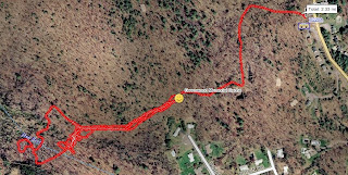
I drove home and had some lunch. Afterward, I decided to try Greenwood Memorial Cache again. BB and I had tried this cache Thursday but DNF. I'd studied the plaques and realized that I might have made a mistake when I solved the stage 1 puzzle. Armed with a new set of coordinates I decided to try again. This was one of THOSE experiences involving 2.33mi of hiking and ANOTHER DNF after walking to the new stage 2 coordinates not finding the cache again, walking back to the graves, calculating another stage 2 coordinate (made a simple error) walking back to the the new new stage 2 not finding it there wandering through the wetland and loosing a glove on the way back to my car.
Occasionally geocaching is like that.
Today (Saturday) I decided to try yet again and hopefully find my lost glove. Before starting out I reviewed the cache logs and photos carefully. I decided to try at another GZ with the 1003 offset and the image of the Girl Scout find. Armed with this new information BB and I went out again and quickly walked in. Sure enough it was at the new new new GZ.
The coordinates for the final are definitely bogus! While at the final stage I took a number of GPS readings under clear skies with good GPS accuracy at the final coordinates and computed a new set of final stage puzzle factors. The N factor I got is 1553 and the W factor is 1000.
I signed the log and BB and I hiked back out.
As usual here are all the photos from this 2 day adventure. There are some spoilers.
Started with Rocky Ridge Multicache. Found it. SL/TNLN/TFTC. I'd checked this out online before departing. There is good parking at the office park S of the cache and a trail leading in. This makes the route only about 2000'.


While I was in the area I decided to try the nearby Send Out Succour to Juniper Hill. There is good parking at the end of Barberry Rd. and it's an easy walk through wetland to GZ for stage 1. You need to cross a number of streams but there are nice plank bridges.

I found stage 1 fairly quickly and got the Morse code for stage 2. My Morse is a bit rusty (being old and a geek is occasionally useful) but armed with the coordinates for stage 2 I continued down the trail. This seemed to lead to someone's yard so I doubled back and returned to a trail heading N toward GZ through the wetland. It was occasionally muddy but passable the day I was there. Eventually the trail turned W toward the stage 2 GZ. This was in an interesting open hill.

I drove home and had some lunch. Afterward, I decided to try Greenwood Memorial Cache again. BB and I had tried this cache Thursday but DNF. I'd studied the plaques and realized that I might have made a mistake when I solved the stage 1 puzzle. Armed with a new set of coordinates I decided to try again. This was one of THOSE experiences involving 2.33mi of hiking and ANOTHER DNF after walking to the new stage 2 coordinates not finding the cache again, walking back to the graves, calculating another stage 2 coordinate (made a simple error) walking back to the the new new stage 2 not finding it there wandering through the wetland and loosing a glove on the way back to my car.

Occasionally geocaching is like that.
Today (Saturday) I decided to try yet again and hopefully find my lost glove. Before starting out I reviewed the cache logs and photos carefully. I decided to try at another GZ with the 1003 offset and the image of the Girl Scout find. Armed with this new information BB and I went out again and quickly walked in. Sure enough it was at the new new new GZ.
The coordinates for the final are definitely bogus! While at the final stage I took a number of GPS readings under clear skies with good GPS accuracy at the final coordinates and computed a new set of final stage puzzle factors. The N factor I got is 1553 and the W factor is 1000.
I signed the log and BB and I hiked back out.
As usual here are all the photos from this 2 day adventure. There are some spoilers.
Thursday, March 4, 2010
BB and I try geocaching
BB was off today. It was rather nice to have her around after several weeks of the software conversions at the hospital interfering with her Thursday day off.
We slept in and after a quiet mourning went out to run errands and go for a cache walk.
We tried again to access Down by the River. We'd tried to go to this cache some while back but were unable to reach it because we couldn't find the trail (it was behind some trucks doing maintenance on the pumping station). I'd been by later and found the trail, so today seemed like a good day ... NOT. Here's what we ran into when we tried to walk to the pipe bridge:
 As you can see, it's under about 18" of water! I tried to find other access but there seems to be a fair bit of posted property on the far side of the river. Oh well, perhaps another time.
We drove back to Sudbury to Karma Coffee. If you've not been there, it has much to recommend it. It's a small coffee roasting and cafe with by far the best dark roast coffee anywhere around.
After a coffee fix, we went over to Greenwood Memorial Cache. This is near where BB had a house before we moved to Sudbury. We got to stage one OK, but I messed up the stage two calculations and, of course, we DNF the final. Sigh. That said it was a nice 1.5 mile walk. Here's a photo of the grave site:
 I pulled one wrong date from the plaques. While we were very near the real coordinates, we were off by enough to miss the find. It's a nice walk though, so I'll go back when a get a chance and find the final.
After our hike, we ran the grocery errand. There was some very nice fish available today, so we'll have a Mexican fish dish for dinner tonight. I should note here, that I don't mean border Mex, but Mexican. If you travel to central or south Mexico, you'll realize that they have fish from BOTH oceans and much of the cuisine reflects French and Spanish cooking (Mexico was part of France at one point). At any event I'm looking forward to a nice dinner.
We slept in and after a quiet mourning went out to run errands and go for a cache walk.
We tried again to access Down by the River. We'd tried to go to this cache some while back but were unable to reach it because we couldn't find the trail (it was behind some trucks doing maintenance on the pumping station). I'd been by later and found the trail, so today seemed like a good day ... NOT. Here's what we ran into when we tried to walk to the pipe bridge:

We drove back to Sudbury to Karma Coffee. If you've not been there, it has much to recommend it. It's a small coffee roasting and cafe with by far the best dark roast coffee anywhere around.
After a coffee fix, we went over to Greenwood Memorial Cache. This is near where BB had a house before we moved to Sudbury. We got to stage one OK, but I messed up the stage two calculations and, of course, we DNF the final. Sigh. That said it was a nice 1.5 mile walk. Here's a photo of the grave site:

After our hike, we ran the grocery errand. There was some very nice fish available today, so we'll have a Mexican fish dish for dinner tonight. I should note here, that I don't mean border Mex, but Mexican. If you travel to central or south Mexico, you'll realize that they have fish from BOTH oceans and much of the cuisine reflects French and Spanish cooking (Mexico was part of France at one point). At any event I'm looking forward to a nice dinner.
Wednesday, March 3, 2010
Geocaching 3/3/2010
I've finally got things working again with the PN40. What a struggle! I ended up having to reformat user data and reload again, but at least things are back working.
This was a rather mixed day with snow, rain, snow, rain, and allegedly 2" of new snow coming overnight. Welcome to New England weather.
I decided to do a multi today, Concord Dozen. I don't do many of these as I prefer the instant gratification of traditional caches. This is one of BugTracer's and he'd mentioned that it was reasonable in winter so I thought I'd have a go.
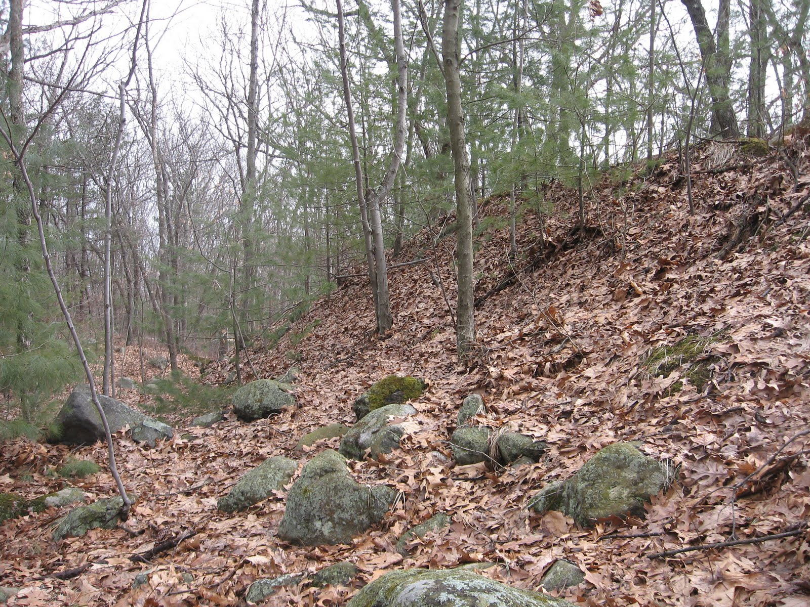
Stage 1 is just off RT 27 by the river. You can actually drive to GZ so this part is very simple. Once there you need a date off of the monument to get to stage 2. While there I took a few minutes to look at the river, very flooded and walk down the old road a bit. Interesting. After I got back to the car I took the date and solved for the reasonably nearby stage 2. Driving was a bit of an issue as the direct route is flooded this time of year. I ended going back to town center to get to stage 2.
Stage 2 is a short drive to some nearby Sudbury Valley Trustee property. It's only a brief walk from the trailhead with some OK small car parking on the side of the road. This is a lovely forest I'd not visited previously. It turns out there is access from the nearby school parking lot which would have provided better parking and a somewhat longer walk. I didn't know this until after I'd already parked on the road. At any event it is only a short walk to the stage 2 GZ. I found stage 2 reasonably quickly. It's definitely NOT snow friendly. It's also a bit rusted but I was able to get it open OK and get the coordinates for the final.
I drove around to the nearby school and parked. It is only another short walk to the final over some rather hilly terrain and then into some VERY wet land where the final is hidden. Boots of some sort are definitely called for. Given the location I suspect it's wet year round. I found it after only a bit of searching and some careful foot placement to get to GZ.
This was not my usual multi-cache day but I'd had other things to attend to and didn't have a lot of time. At any event, I've put a found next to this cache.
As usual here are all the photos. WARNING! I've only posted a link since there are serious spoilers here.
This was a rather mixed day with snow, rain, snow, rain, and allegedly 2" of new snow coming overnight. Welcome to New England weather.
I decided to do a multi today, Concord Dozen. I don't do many of these as I prefer the instant gratification of traditional caches. This is one of BugTracer's and he'd mentioned that it was reasonable in winter so I thought I'd have a go.
Stage 1 is just off RT 27 by the river. You can actually drive to GZ so this part is very simple. Once there you need a date off of the monument to get to stage 2. While there I took a few minutes to look at the river, very flooded and walk down the old road a bit. Interesting. After I got back to the car I took the date and solved for the reasonably nearby stage 2. Driving was a bit of an issue as the direct route is flooded this time of year. I ended going back to town center to get to stage 2.
 |  |
| Route within Sudbury | You can drive to the stage 1 monument |
 |  |
| The river was seriously high today | There's parking for a few cars but it could get muddy |
Stage 2 is a short drive to some nearby Sudbury Valley Trustee property. It's only a brief walk from the trailhead with some OK small car parking on the side of the road. This is a lovely forest I'd not visited previously. It turns out there is access from the nearby school parking lot which would have provided better parking and a somewhat longer walk. I didn't know this until after I'd already parked on the road. At any event it is only a short walk to the stage 2 GZ. I found stage 2 reasonably quickly. It's definitely NOT snow friendly. It's also a bit rusted but I was able to get it open OK and get the coordinates for the final.
 |  |
| Property trail map showing parking at nearby school | Near GZ |
I drove around to the nearby school and parked. It is only another short walk to the final over some rather hilly terrain and then into some VERY wet land where the final is hidden. Boots of some sort are definitely called for. Given the location I suspect it's wet year round. I found it after only a bit of searching and some careful foot placement to get to GZ.
 |  |
| Cut through playground to get to trails | Near GZ things get really wet. Boots are definitely wanted. |
 |  |
| At first I thought it was here. It's NOT. | Perhaps over there somewhere; if you can get to it without getting wet. |
This was not my usual multi-cache day but I'd had other things to attend to and didn't have a lot of time. At any event, I've put a found next to this cache.
As usual here are all the photos. WARNING! I've only posted a link since there are serious spoilers here.
 |
| 2010-03-03 Geocaching |
Tuesday, March 2, 2010
Geocaching 3/2/2010
After speaking with Delorme again about the Cache Register/geocaching.com issue I tried their 'fix'. I'd tried it previously without luck but just to be sure I tried it again. While the caches now load as caches not waypoints, the names are GCxxxx codes not the actual cache name. Sigh! Hopefully, there will be a fix sometime soon.
Notwithstanding the issue, I went out and had a pleasant afternoon in the mild weather. Here's where I went.
homies - DNF. There were signs of considerable flooding from the recent rain near GZ. If the cache was down low it may have been washed away. I'll put a watch on it and see if anyone else has any luck.
Tick Free 7 - Found it. SL/TNLN/TFTC. This is a nice park and grab that is certainly snow friendly.
Attack 01 of the Almonds - Found it. SL/TNLN/TFTC. I'd never been to this conservation land before. It's really charming with the stream and many interesting rock outcroppings. This cache is a park and grab but not snow friendly and was easily found.
Garfield Woods - Found it. SL/TNLN/TFTC. Continuing into the conservation land this is a charming walk. I made the mistake of bushwacking instead of staying on the blue trail. While the walk was a bit more challenging, it did take me past some interesting rock outcrops and glacial erratics. I had to go a bit off trail to get around some flooding on the way out.
Torch Tuber - Found it. SL/TNLN/TFTC. On the way back home I stopped at this Bolton town land. The path in goes around a lovely small pond with this cache just on the other side of the dam. It was completely exposed and clearly visible. I signed the log and then re-hid the cache with some additional cover material. While the cache is easily accessed, it is not snow friendly.
Fyfeshire Conservation - Found it. SL/TNLN/TFTC. Continuing down the path from Torch Tuber and around a larger pond I quickly found the cache. Interestingly, there was some evidence of recent beaver activity. The cache is not snow friendly.
I reconnoitered a couple of other caches on the way home. But it was getting a bit late so I didn't stop.
Here are all the photos from today's adventures.
Notwithstanding the issue, I went out and had a pleasant afternoon in the mild weather. Here's where I went.
homies - DNF. There were signs of considerable flooding from the recent rain near GZ. If the cache was down low it may have been washed away. I'll put a watch on it and see if anyone else has any luck.
 |  |
| Parking at apartments. | Some signs of flooding. |
Tick Free 7 - Found it. SL/TNLN/TFTC. This is a nice park and grab that is certainly snow friendly.
 |  |
| Parking looks plowed but was muddy today | Very snow friendly |
Attack 01 of the Almonds - Found it. SL/TNLN/TFTC. I'd never been to this conservation land before. It's really charming with the stream and many interesting rock outcroppings. This cache is a park and grab but not snow friendly and was easily found.
 |  |
| Yet another wonderful Sudbury Valley site | Near GZ. Not snow friendly. |
Garfield Woods - Found it. SL/TNLN/TFTC. Continuing into the conservation land this is a charming walk. I made the mistake of bushwacking instead of staying on the blue trail. While the walk was a bit more challenging, it did take me past some interesting rock outcrops and glacial erratics. I had to go a bit off trail to get around some flooding on the way out.
 |  |
| Route I took. Stay on blue trail don't bushwack! | Found it. |
Torch Tuber - Found it. SL/TNLN/TFTC. On the way back home I stopped at this Bolton town land. The path in goes around a lovely small pond with this cache just on the other side of the dam. It was completely exposed and clearly visible. I signed the log and then re-hid the cache with some additional cover material. While the cache is easily accessed, it is not snow friendly.
 |  |
| Cache was completely uncovered | I added some hide material |
Fyfeshire Conservation - Found it. SL/TNLN/TFTC. Continuing down the path from Torch Tuber and around a larger pond I quickly found the cache. Interestingly, there was some evidence of recent beaver activity. The cache is not snow friendly.
 |  |
| Recent beaver activity near GZ | Hid it a bit better |
I reconnoitered a couple of other caches on the way home. But it was getting a bit late so I didn't stop.
Here are all the photos from today's adventures.
Geocaching 3/1/2010
I called Delorme today to check into the issue with Cache Register and geocaching.com. After a rather long hold time I finally got a support tech. He didn't seem to be aware of the issue! We chatted for a bit and he indicated that he would check with development to make sure they were working the problem. Not especially encouraging! We'll see what happens.
Faced with possible problems with Cache Register I decided to explore GSAK as an alternative. Many cachers use this program and speak well of it. After a bit of experimentation I was able to load caches reasonably and subsequently unload cache status. Unfortunately, cache status was NOT updated on GC.com and it looks like the field notes in the GPSr are not uploaded as is done with Cache Register. That's a bummer but not necessarily a deal breaker if CR continues to be broken.
I did go out today to try to find at least one cache, Babe Ruth's Piano. Parked off of Old Marlborough Rd. at N42° 24.5591' W71° 26.9502'. It looks like it is probably plowed with space for a number of cars. Nearby is some sort of interesting federal facility surrounded by a fairly serious fence.
I walked in on the L road heading south. This is an interesting old road of some sort surrounded on both sides by marsh.
Along the way I passed some geese and a beaver hutch. Very interesting.
I had to bushwack through some very nasty thorns to get around a flooded area.

A bit further along I got to a side trail headed toward GZ. Just a bit along the trail is the 'Babe Ruth' side.
A bit of searching and the hint found stage 1 with coordinates to the very nearby final. I had a bit of misadventure when I entered a partially wrong coordinate that put the final 50 miles away. I knew this wasn't right and after a bit of puzzling put the right coordinates in and quickly found the final.
After signing the log and replacing the cache I decided to continue along the road and come out via the Assabet perimeter road. This allowed me to avoid the flooded area and have a bit of a longer walk. This longer route lovely walk over nice trails and past both a pond with fishing and extensive wetlands was very nice.
This is a very nice cache. I'm a bit surprised that it is not visited more often.
As usual here are all the photos from this adventure.
Faced with possible problems with Cache Register I decided to explore GSAK as an alternative. Many cachers use this program and speak well of it. After a bit of experimentation I was able to load caches reasonably and subsequently unload cache status. Unfortunately, cache status was NOT updated on GC.com and it looks like the field notes in the GPSr are not uploaded as is done with Cache Register. That's a bummer but not necessarily a deal breaker if CR continues to be broken.
I did go out today to try to find at least one cache, Babe Ruth's Piano. Parked off of Old Marlborough Rd. at N42° 24.5591' W71° 26.9502'. It looks like it is probably plowed with space for a number of cars. Nearby is some sort of interesting federal facility surrounded by a fairly serious fence.
 Route, about 2 miles |  Federal facility near parking |
I walked in on the L road heading south. This is an interesting old road of some sort surrounded on both sides by marsh.
 Road |  Marsh |
Along the way I passed some geese and a beaver hutch. Very interesting.
 Geese |  Beaver hutch |
A bit further along I got to a side trail headed toward GZ. Just a bit along the trail is the 'Babe Ruth' side.
 Side trail |  'Babe Ruth' house |
 Stage 1 |  Final |
 Final. Camo tape gone. |  Cache in good order |
 Fishing in this pond |  Extensive wetlands |
As usual here are all the photos from this adventure.
Subscribe to:
Posts (Atom)